Rare Books
The western traveler's pocket directory and stranger's guide : exhibiting distances on the principal canal and stage routes in the states of New-York and Ohio, in the territory of Michigan and in the province of Lower Canada, &c. ; containing also descriptions of the rail roads now building and in contemplation in this state ; with a list of broken banks, rates of toll on the canals for 1834, and a variety of other matter highly valuable to the traveling community
Image not available
You might also be interested in
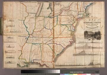
Map of the railroads and canals finished, unfinished and in contemplation in the United States
Rare Books
First alternate title from cover. Second alternate title and pub date from cover page. Optimistically sited contemplated canals included. Descriptive section included in cover. Crossectional views of canal and railroad lines. Prime meridian: Washington. Relief: no. Graphic Scale: Miles. Projection: Cylindrical. Printing Process: Copper engraving.
8743

The traveller's guide or the map of the roads, canals & rail roads of the United States with the distances from place to place by H.S. Tanner
Visual Materials
Image of a map of the Eastern United States showing roads, canals, and railroads with eleven inset maps of the environs of Albany, Saratoga, &c., the Falls of Niagara &c, Quebec, Providence, Boston, Richmond, New York, Charleston, Baltimore and Washington, Washington, D.C., and Philadelphia; with references for Washington D.C. numbered 1-10 and references for Philadelphia numbered 1-6 and a-p.
priJLC_TRAN_001189